
|
|
|
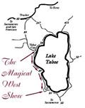
Summer Wandering Lake Tahoe's West Shore
|
|
|
|
|
Tahoe Country Mail |
 |
|
|
|

|
|
|
|
|
THE "Magical West Shore" may sound like a term straight out of travel agent school, but spend a week or a weekend on the stretch of Lake Tahoe between Tahoe City and Emerald Bay and you may fall under the same spell that draws many visitors back summer after summer.
The West Shore is the Tahoe of granite and centuries-old cedars, cobalt-blue bays, quaint knotty-pine A-frames and grandiose lakefront estates. This is the Tahoe where how much recreation you can pursue on any given summer day is limited only by how much sleep you need.
Throw a dart at a map of the West Shore and anywhere it lands won't be far from fishing, hiking, camping, rock climbing, in-line skating, water skiing, parasailing, mountain biking, four-wheeling and a host of other activities. If all that poops you out, you can doze in the sun on a sandy beach, then take in cocktails or dinner at a selection of eateries that serve everything from full-course gourmet meals to black bean burritos. Then you can sleep it off in accommodations that range from campsites at water's edge to $240-a-night luxury cottages. And despite all the action for those who crave it, even when it's crowded by local standards, the West Shore, four to five hours by car from most of the Bay Area, remains a relatively tranquil place.
Getting
acquainted:
The logical place to start your tour of the West Shore is the "Y" in Tahoe City,
where Highway 28 forks off Highway 89 and heads for Nevada. Stay on Highway
89 and head south. You'll cross the Truckee River at Fanny Bridge, named after
what you see of the tourists who often line the sidewalk on the lake side to
ogle the monster rainbow trout awaiting handouts. In summer, you can rent
rafts for the self-guided, two-hour float trip to River Ranch, at the entrance
to Alpine Meadows.
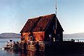
On the South side of the inlet lies the old Gatekeeper's Cabin, currently a museum of Tahoe memorabilia and an impressive Indian basket collection. Admission is free. As you leave Tahoe City, you'll notice the bike trail that parallels Highway 89 for most of the distance between Squaw Valley and Sugar Pine Point State Park. At times, the trail crosses the highway or is just a lane on the highway, but most of the way it's a wide, smooth path that gets plenty of use by skaters and runners as well as bicyclists. If you want to ride from Tahoe City to trail's end and back, there's a parking lot on the west side of Highway 89 about a quarter-mile south of Fanny Bridge. You can rent bikes at several points along the trail.
On to Sunnyside:
Below Tahoe City, the highway winds among firs and pines and passes through
Sunnyside, the most commercial of the West Shore's communities, with a couple
of markets, restaurants, a resort; power boat, jet ski and sailboat rentals
and opportunities to fish for Tahoe's big lake trout.
Camping is available at the U.S. Forest Service's William Kent Campground on
the west side of the highway, and there's a picnic area and beach on the lake
side.
Just south of Sunnyside, look for Pineland Drive, which will take you toward Alpine Peaks, where you can park at several points and hike along Ward Creek. A little farther up the road, you'll encounter stunning views of granite crags to the south and see why residents tolerate the snow that inundates the area. At the end of the road is the back side of Alpine Meadows Ski Resort and its Sherwood chair lift. This is the trailhead for steep but rewarding hikes to Twin Peaks, Ward Peak and others. Go far enough west and you'll hit the Pacific Crest Trail.
A more popular gateway to the high country is Barker Pass Road, two miles south of Sunnyside, which takes you into Blackwood Canyon. The first few miles of the road are straight and fairly level, with smooth pavement that makes it popular with in-line skaters. There's plenty of parking at the highway. In a couple of miles, the road crosses Blackwood Creek and begins a rather steep climb to Barker Pass, about nine miles west of Highway 89, where the pavement ends. You can park at the pass and hike up 8,754-foot Ellis peak. A half-mile farther, where the Pacific Crest Trail crosses the road, is a larger parking lot. This is a good jumping-off point for mountain bikers of all skill levels, although they are not allowed on the PCT. Beginners will have a blast exploring the logging roads that crisscross the area, and more advanced riders will be challenged by heading southwest and linking up with the Rubicon jeep trail. Maps and a good sense of direction are a must.
A meal
and a view:
Back at the highway, the Kaspian Picnic Area is a good place to grab a quick
bite and watch for the vintage wooden speedboats that often ply the waters of
the West Shore. Another quarter-mile south of Kaspian-Blackwood is Eagle
Rock, the well-known promontory that sits just to the west of the highway.
The best parking is south of the rock, but the easiest route to the top is from
the north. With a little help and encouragement, even small kids can make it
to the top and look down at how the other half lives in some of the area's lakefront
estates. A good example of
that lifestyle is available half a mile south of Eagle Rock at Fleur du Lac,
a walled compound of multimillion-dollar homes that was fashioned from cement
magnate Henry Kaiser's 18-acre retreat. You can park along Highway 89 or Grand
Avenue to the north of the compound and peer discreetly through gates at the
opulence that served as one of the locations for "The Godfather, Part II."
Homewood:
Next stop is Homewood, another cluster of development, with a marina, motels,
market and tourist attractions such as seaplane rides and charter fishing. If
you're into four-wheeling, about eight miles south of the "Y" look for a brown
road sign that directs you to "Rubicon-McKinney OHV Access." Turn west here
and follow the signs to the turn-off for Miller Lake. This is the eastern terminus
of the famous Rubicon jeep trail that begins on the other side of the Sierra
at Wentworth Springs near Loon Lake. There are a few rough patches as you head
west, but the road isn't a serious four-wheel-drive challenge until after you
cross the Sierra crest and head down toward Rubicon Springs.
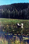
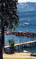
You can also hike or mountain-bike to the lily-covered lakes that lie along the first few miles of the eastern end of the road, but be prepared to put up with the dust and fumes from the jeeps. Rustic campsites are available. If you interested in fishing in the backcountry, it's best to hire a local guide. Just south of Homewood, at Chamber's Landing, you'll find a sandy public beach and Lake Tahoe's first bar (1875) which is still in use.
Tahoma:
Tahoma, about nine miles south of
the "Y", is the last real town on the West Shore. Here you'll find a handful
of restaurants and bed-and-breakfasts that have changed the image of the rustic
little hamlet whose main claim to fame once was that it had more canine residents
than human ones. You can also rent homes: from quaint little cabins to lakefront
luxury homes. On Saturday nights in the summer, the locals show free family
movies on a big screen at Marie
Sluchak Community Park on Pine Street, just off the highway. Check the bulletin
board there for titles and times and arrive early; it's amazingly popular. They
also have church services on Sunday mornings.
Below Tahoma, the buildings thin out and you enter Sugar Pine Point State Park, where, on the west side of the highway, you can camp beneath giant evergreens and hike, bike or fish along General Creek. More ambitious walkers head for Lost Lake, which is seven miles and a good climb away.
On the lake side of the highway is Sugar Pine's day-use area ($5 per vehicle), where you'll find the Ehrman Mansion, a huge timber-and-stone lodge that was built as the summer home for I.W. Hellman, a San Francisco banker. Free hourlong tours of the well-preserved mansion are offered 11 a.m.-4 p.m. daily from June 29 through Labor Day. Kids will enjoy the park's Nature Center, a museum with wildlife displays that is lodged beneath the old mansion's water tower.
Meeks Bay:
Meeks Bay, or Magulu
Watah as called by the Washoe Indians, the first to enjoys its shores, lies
about a mile south of Sugar Pine. There you'll find a large strip of sandy beach,
camps grounds and cabins to rent, and a grocery store.
Across the highway from Meeks Bay is a trailhead to the Desolation Wilderness
Area. Day hikers and those wishing to fish
can get an entrance permit at the kiosk there. Make sure you do. Rangers routinely
ask to see them. Overnighters in Desolation need to get a permit at the Forest
Service office in South Lake Tahoe (870 Emerald Bay Road, 530-573-2600) or the
kiosk at William Kent Campground in Sunnyside. Permit in hand, you can head
along Meeks Creek up the fairly forgiving trail to such backcountry lakes as
Genevieve, Crag and Stony Ridge. By midsummer, the water in these lakes is more
pleasant for swimming than Tahoe.
D.L. Bliss
State Park:
A hike more suited for small children is on the nature trail at D.L. Bliss State
Park, about six miles south of Meeks Bay. The centerpiece of the trail is Balancing
Rock, a huge granite orb perched precariously atop another. The trail can be
reached by driving into the Bliss campground or by parking along Highway 89
in one of the pullouts on the east side of the road.
A cove for
the kids:
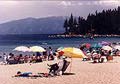
Bliss also boasts what is arguably the best Tahoe beach that you can drive to.
But you'll have to get there early. Rangers limit the number of cars allowed
to pay the $5 day-use fee and drive to the parking area near the beach. There's
a large strip of sand with a swimming area and a rocky cove that's fun for kids
to explore. You can also get
to the beach by water, but if you're lucky enough to be traveling by boat, there
are more secluded coves between Bliss and Emerald Bay that you may prefer -
including one where a little waterfall spills into the lake. Don't have a boat?
You can explore the shoreline between Bliss and Emerald Bay on foot. A mostly
level trail covers the 4.4-mile distance, leading the hiker high above rocky
inlets. Even in peak season, the trail is remarkably uncrowded.
Emerald
Bay State Park:
If that hike is too much, drive a few miles south of Bliss to the parking lot
at Emerald Bay. Again, in the peak months of July and August, arrive early as
the lot fills quickly. From the lot, it's a 1.5-mile stroll down a wide, paved
trail to Emerald Bay. There are picnic tables and a small beach. But the main
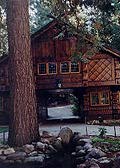
attraction is Vikingsholm, a 38-room Scandinavian mansion that was built in
the late 1920s. Tours are offered daily from June 15 to Labor Day at $2 for
adults and $1 for kids 6-12. They start on the half-hour from 10 a.m. to 4 p.m.
The remains of a stone tea house sit high atop Fanette Island in the middle of the bay. You can visit by boat. Resist the temptation to swim to the island; every year, swimmers unaccustomed to the lake's 6,229-foot elevation and the chilly water get into trouble. Across the highway from the Vikingsholm parking lot is the Eagle Falls trailhead, another popular entry point into the Desolation Wilderness. It's a few hundred yards to the falls and an easy mile to granite-bound Eagle Lake. Beyond that, the trail climbs steeply for a while, taking hikers into the heart of the wilderness area with its scores of lakes and snow-capped peaks. Rock climbers frequent this area.
Two options
for hiking:
A good place to end your tour of the West Shore is at the Bayview Trailhead
on the south side of Emerald Bay. From here, you can make the easy one-mile
trek to the top of spectacular Cascade Falls or take another, much steeper trail
into Desolation via Granite Lake. The views of Emerald Bay are stunning.
STORY: by Mike Stuckey - Used here
with permission.
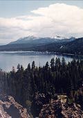
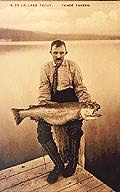
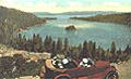
IMAGES: (top to bottom) West Shore from Eagle Rock, Jill Beede; map; Gatekeeper's
Cabin Museum, Jill Beede; vintage postcard, Dee Macrae collection; Lily Lake,
Jill Beede; Chamber's Landing bar, Cathy Carew; black bear, Dan Bartley; Sugar
Pine Point pier, Jill Beede; Meek's Bay beach, Pat Davi; Vikingsholm, Jill Beede;
vintage card, Dee Macrae collection.
For related businesses, see the Tahoe
Country Directory.