
|
|
|
 |
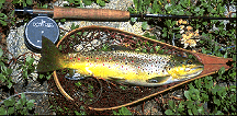
The Tahoe-Yosemite Trail leaves Meeks Bay for Yosemite and is a well-developed major Sierra route. There are fish in Meeks Creek but overgrowth makes it hard to fish until you reach the first lake at 4.6 miles in. At this point there are a series of lakes all of which provide fine fishing. This part of the Desolation is known for browns and Crag Lake has some fine fish (see below) that move for minnow imitations. At the top of Phipps Pass is Phipps Lake that is known for excellent brookie fishing. This is primarily an overnight camping area due to the distance to the first lake and requires a wilderness permit. Day permits are available at trailheads but overnight permits must be obtained from a ranger station. The two most convenient are on Highway 50 near Placerville (916-644-6048) and in South Lake Tahoe (916-573-2600). If you are planning to stay overnight, call ahead of time and determine the best way to obtain a permit for your trip.
 |
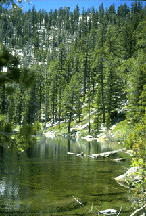
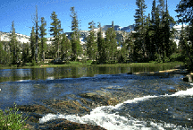
The next main area is the Eagle Lakes Trail that heads in from Emerald Bay. There is also a secondary entrance on the Bayview Trail just south of Emerald Bay. The main attraction here would be the Velma Lakes about 5 miles in. These are stocked with put and grow rainbows which at maturity often reach 15". They are particularly susceptible to damselfly imitations in July and terrestrials, especially grasshoppers, at any time. This is probably the most overused area in the Desolation and is not a place for solitude. Nonetheless there are many secondary lakes that offer a place to get away from it all. For example, Granite Lake up the Bayview Trail a little over a mile has plenty of brookies. Due to the steepness of the trail, it is not often fished (top photo is Granite). A float tube is very useful in this and other lakes of the Desolation. Below is a view of the stream between Upper and Lower Velma Lakes in this drainage (photo won Landscape Category Flyfishing@ photo contest 1995).
 |
We next move into the Fallen Leaf Lake area. The main trail in this section goes up the entrance creek to Fallen Leaf at the far end of the lake. Although some fishing can be done in the creek it requires much local knowledge. Very good fishing, however, is available up the trail at Susie (brookies) and Heather (brookies and browns) Lakes. These fish are after minnows and have been taken in over 17" size in both lakes. Brookies fishing slows down after July 1st (depending on snowpack) as the water warms and one is best off searching for a lake with rainbows that still surface feed in the middle of summer.
The next drainage is Echo Lakes. One of the best points about this entrance is the water taxi that is available out of Echo Lakes Lodge. The folks there will for a modest fee drop you at the head of the lakes and make arrangements to pick you up later. This saves miles of hiking and makes it ideal for a day trip. Tamarack Lake is the closest lake to the end of the water taxi route and suffers from over use. However, right next to Tamarack are Ralston and Cagwin Lakes that provides less used alternatives with plenty of fish and solitude. The people at the Lodge can give you some information about local conditions depending on what time of year you go.
Continuing down Highway 50 the next useful entrance is the trail for Horsetail Falls from Twin Bridges. This very steep trail is only for experienced and confident hikers (see USFS warnings). From its top there are a number of small pretty lakes within easy walking distance (assuming you get an early start). One of the more interesting lakes up here is lake of the Woods that is heavily used but has large fish and extensive weedbeds. This lake can also be reached from the Echo region but from either entrance is a very long day-trip. Most of the small lakes in this area have brookies and provide pleasant recreation. The number of people on the Horsetail Falls entrance fall off rapidly as one gains altitude.
The next major entrance is the Wright's Lakes region. There are several major trails leading out of this areas. Suffice it to say that in general the first lake on each trail has the worst fishing, but there is very good fishing to be had as you move up with altitude and away from Wright's Lake itself. One pleasant afternoon can be had, for example, by using the Lyon's Lake trail to reach that lake, known for its large brookies, or to move a little further up to Lake Sylvia. This later lake provides the best base camp to climb to the top of Pyramid Peak and has many, probably too many, small brookies. They readily take small attractor dry flies.
There are several obvious access routes into this isolated
area. Luckily for solitude most of the routes involve such distance as to
make day trips impossible. This area approximates what the "real" Sierra looks
like, i.e. few people and plenty of cross-country route. Just to mention one
of the more interesting lakes, Clyde, is at the headwaters of the Rubicon
River. It has been stocked with goldens for many years and they have spread
into the river downstream. This provides even the novice angler for a chance
to catch a golden in a stream. I should say that catching them bin a lake
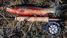
is much harder. Below is an example of a larger than average Golden from the
Desolation.
|
Further information can be obtained from the Desolation Wilderness Fishing Guide. Proceeds from the book are to be used to further biological studies of the area which has been a hotbed of controversy about the interactions of fish and amphibian populations in the High Sierra. For example, we recently partially funded a joint DFG/USFS pack trip to study several frog populations in the Wilderness.
By Jerry Yesavage, CalTrout Streamkeeper for the Desolation Wilderness
More fishing articles, Tahoe Country
OUT N'ABOUT
Shop our Tahoe Country Store Online

Or visit our store in South Lake Tahoe at: 3339 Lake Tahoe Blvd (map)
©
1996-2003 (Jill
Beede)
TahoeCountry.com