SUGAR BOWL - SQUAW HIGH ROUTE
DATE:
APRIL 2000
By: Erik Riegler
Background: The route described is a moderately difficult 12-mile section of the Pacific Crest Trail which runs along a spectacular ridgeline between Sugar Bowl Ski Resort and Squaw Valley Ski Resort. In winter, it requires good traverse skiing and backcountry navigation skills, as the trail and trail markers are not visible. It can be done in either direction, but the route described here goes from Sugar Bowl to Squaw Valley. Although it can be accomplished in one long day, the usual way is to spend a night at the Benson Hut, a rustic Sierra Club hut nestled into the north slope of Anderson Peak, about 3.5 miles from the boundary of Sugar Bowl and 4.5 miles from the boundary of Squaw Valley. Reservations for the Benson Hut are $8 a person and can be made by phone at the Claire Tappan Lodge at (530) 426-3632.
USGS Topo Maps: Norden (7.5") and Granite Chief (7.5").
Getting There: Take Highway 80 east out of Sacramento. Before Donner Summit (which drops down into Truckee), take the Soda Springs exit and turn right (south). Follow the road a couple of miles to the Sugar Bowl Ski Resort.
The Route: At Sugar Bowl, either take the lift or ski up the resort trails to the top of Mt. Lincoln (8,383'). From the top, follow the prominent ridgeline to the southeast for approximately 3 miles to the southeast to Anderson Peak (8,683'). Stay to the west of the ridgeline, as the prevailing west winds often form cornices over the eastern lip of the ridge. The Benson Hut is nestled on the north shoulder of Anderson Peak at treeline (approx. 8,320'). The hut has upper and lower rooms, a wood burning stove and firewood. There is no running water or electricity, and no permanent residents there.
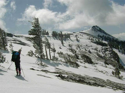
From the Benson Hut, one can either climb up and over the top of Anderson Peak or angle around the west side above treeline to the southern flank, where the ridgeline continues to the southeast for 1.5 miles to Tinker Knob (8,949'). This ridgeline has spectacular views both to the east of the mountains surrounding Lake Tahoe and to the west of the Sierras and, on a clear day, the central valley. The route curls around the east flank of Tinker Knob and then begins a gradual traversing descent for about 2.5 miles to Mountain Meadow Lake (7,900'). A quarter mile beyond the lake, take the gully which steepens before running into Squaw Creek and the ski lifts of Squaw Valley. From here, it is possible to ski out through Squaw Creek or take a lift and ski down the main runs at Squaw Valley.
The Photo: The photo is of backcountry skier Landon Browning traversing the ridgeline running between Anderson Peak and Tinker Knob, which had just received an overnight dusting of spring snow. Just a few yards ahead on the ridgeline were pan-sized bear tracks made earlier that morning.
Story and photos by: Erik Riegler