Ralston Peak (9,235') in Desolation Wilderness

Ralston Peak (9,235') in Desolation Wilderness |
|
Background:
The route described is a picturesque and fun day trip off Highway 50 (6,600')
to the top of Ralston Peak (9,235') in Desolation Wilderness near Lake Tahoe.
It runs along the southern flank of Ralston Peak with spectacular views to the
west of Pyramid Creek canyon and, higher up, of the Crystal Range and Desolation
Valley. It can be accomplished in a day or can be the start of a multi-day snow
camping trip in the Desolation Wilderness. For multi-day trips, stop for a permit
at the El Dorado National Forest Information Center located just off Highway
50 on Camino Heights Drive a few miles east of Placerville. The Center's phone
number is (916) 644-6048.
Getting There:
Take Highway 50 east out of Sacramento. Approximately 1.5 miles after the small
town of Twin Bridges, take the turnoff to the left (north) towards Pinecrest
Camp and follow the main road up to a small bridge over Tamarack Creek at about
6,600'. Park at the roadside near the bridge. If you drive past the bridge,
you will be on church property, and the church people will probably ask you
to park on the other side of the bridge.
 The
Route:
The
Route:
At the bridge, walk about
100 yards up the road and begin skiing up the moderate slopes to the northwest
through the trees. By angling to the northwest, you will soon reach the Ralston
Trail, which runs upwards along the ridgeline. If visibility is poor, stay well
to the east of the ridge, because it drops sharply to the west for over 1,000'
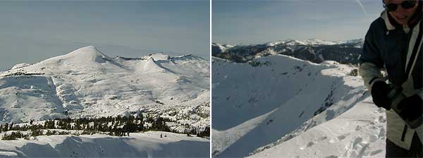
to Pyramid Creek. The photo at right features two telemarkers taking a rest
on the climb up the ridge, surveying the mighty chasm between Ralston Peak and
Pyramid Peak. Continue up the ridge until the angle steepens and then begins
to flatten out. To the northwest you will see the wide open east face of Pyramid
Peak and the high bowl of Desolation Valley.
The Descent:
From the peak, a variety of
descents are available. Along the northwest shoulder of Ralston Peak are a number
of fine north-facing descents of varying angles dropping down into Ralston Lake.
To the south is the wide bowl leading down Tamarack Creek and back to the car.
The Photos:
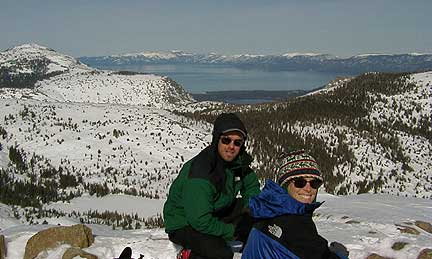
The photo at top shows the
spectacular view from the summit to the north, including Lake Tahoe in the distance
and a bit of Fallen Leaf Lake. The photo (below left) shows the view from the
summit to the west, including the giant east face of Pyramid Peak (in the center)
and Mt. Price (on the right). The photo (below right) shows the very steep southeast
shoulder of Ralston Peak.
Story and photos by: Erik Riegler
Back to Tahoe Country's
OUT N'ABOUT
Tahoe Country HOME
About
Tahoe Country
Advertise | Arts
& Crafts | Business
Directory | Calendar
| Flora
& Fauna | Home
& Garden
Home
Page | List
your Business | Newsletter
| Old
Time Tahoe | Out
n' About | Reader's
Corner | Related
Links
Site Map | Submit
Content | Tahoe
Country Store | Version
Française | Visitor's
Forum | Webmaster
![]()
© 1996-2000 (Jill
Beede)
TahoeWebServices.com