Fishing at Heather Lake

|
Fishing at Heather Lake |
|
CAMPSITE: LAKE ALOHA
DATE: OCTOBER 7-8, 2000
Background: I took all the photos in Desolation Wilderness on the weekend
of October 7-8, 2000.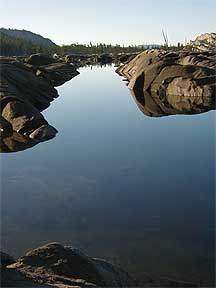
Desolation Wilderness:
Desolation Wilderness is
a 63,475-acre wilderness area located just south and west of Lake Tahoe. It
is a little-known secret of the Tahoe area - with great views of South Lake
Tahoe, excellent hiking trails (the Pacific Crest Trail runs through it),
beautiful secluded lakes, some of the highest peaks in the Tahoe area (Pyramid
Peak at 9,983'), rock climbing, fishing, and awesome glacier-carved granite
formations.
October is a great time to visit Desolation - the temperature was 70 degrees in daytime, a brisk 35 degrees overnight. The summer crowds have thinned out by then; we saw only a few other groups the whole weekend. Dogs are allowed, since it's not a national park. That late in the season, the evenings were chilly enough that mosquitos were no longer a problem.
Getting There: Take Highway 50 east out of Sacramento. Before Echo Summit (which drops down into South Lake Tahoe), take the Echo Lake turnoff heading north, drive about a mile and park at the parking lot at Echo Lake. There is a store and docks there - although the store was closed for the winter when we arrived. During summer, there is a lake taxi which, for $7 apiece, takes you across lower and upper Echo Lake, about 3 miles. The taxi does not run regularly after September, but we were able to gather a group of 4 together and convince the taxi operator to ferry us across. Also, this time of year the channel between lower and upper Echo was too low to provide passage; so we were dropped off at the far end of lower Echo Lake (about 2 miles).
The Trail/Campsite: At the far end of Echo Lake, we joined up with the Pacific Crest Trail heading northwest, passing upper Echo Lake, Tamarack Lake, Lake of the Woods, Lake Margery and Lake Lucille. The trail gradually gains about 800 feet of elevation, crests at Haypress Meadows and slopes gradually down into stark, beautiful Aloha Basin. The trail winds through picturesque pine glens and meadows which are gradually replaced with Yosemite-like cool grey granite shelves and boulders. Through the pine trees emerges Lake Aloha, which is two miles long and a mile wide, sitting in a wide granite basin between Pyramid Peak, Ralston Peak, Jacks Peak and Mt. Price. There are several wonderful secluded campsites along the shore of Lake Aloha, offering spectacular views of the entire Aloha Basin with Pyramid Peak in the background.
 The
Photos: The photo (above right) is of Lake Aloha with absolutely no wind
and excellent early morning sunlight. Lake Aloha is low at this time of year,
so you can get across the lake by hopping along the granite outcrop islands
that are usually underwater.
The
Photos: The photo (above right) is of Lake Aloha with absolutely no wind
and excellent early morning sunlight. Lake Aloha is low at this time of year,
so you can get across the lake by hopping along the granite outcrop islands
that are usually underwater.
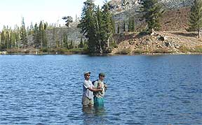
The fly fishing photo at top, is of Erik Riegler and Greg Baumann in Heather Lake, where we caught two brown trout of 12-14" and had nibbles from a larger brown. We cleaned the fish, seasoned the filets, wrapped them in tin foil and baked them for 10 minutes on an MSR stove - excellent eating.
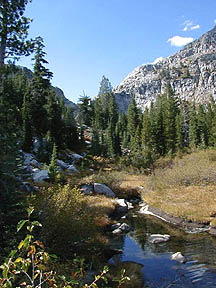
The photo on the left, entitled "Heather Creek", is a shot of the creek from Aloha Basin to Heather Lake, taken from where the creek runs into Heather Lake.
A permit is required to camp overnight - which can be obtained at the Ranger Station just off Highway 50 east of Placerville (take the Camino Heights turnoff to the right; it's a stone's throw from the highway; (916) 644-6048). No open fires, though camp stoves are allowed.
Story and photos by: Erik Riegler
Back to Tahoe Country's
OUT N'ABOUT
Tahoe Country HOME
About
Tahoe Country
Advertise | Arts
& Crafts | Business
Directory | Calendar
| Flora
& Fauna | Home
& Garden
Home
Page | List
your Business | Newsletter
| Old
Time Tahoe | Out
n' About | Reader's
Corner | Related
Links
Site Map | Submit
Content | Tahoe
Country Store | Version
Française | Visitor's
Forum | Webmaster
![]()
© 1996-2000 (Jill
Beede)
TahoeWebServices.com