Castle Peak (9,103') off Interstate 80 |
|
|
|
|
|
|

Background:
The route described is an overnight trip in the popular and scenic skiing/snowshoeing
area at Castle Peak. The area is heavily used on weekends and the main trail
to Castle Pass is obvious, unless a storm has just obliterated it. At Castle
Pass, the trail branches off with the left fork heading north for a mile to
the Sierra Club’s Peter Grubb Hut
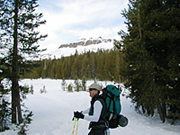
and the right fork heading northeast up the ridge towards Castle Peak. The photo
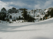
a at top shows Castle Peak from the trail about a mile from the trailhead.
Getting There:
From
Sacramento, take Interstate 80 east to the Castle Peak/Boreal Ski Resort exit,
after the turnoff to Soda Springs and before Donner Pass. If you are doing a
day trip, park at the turnoff on the north side of the highway, where the snow
begins. If you are doing an overnight trip, buy a Sno-Park permit and park at
the Sno-Park on the south side of the highway.
USGS Topo Map:
Norden (7.5").
The Route:
From the trailhead (7,200’), the trail heads northwest for about 2 miles,
slowly gaining elevation along Andesite Ridge on the southwest slope of Castle
Valley, to Castle Pass (7,880’). From the pass, head northeast up the ridge
towards Castle Peak. On the left you will seeRound Valley, the open meadow next
to the Peter Grubb Hut, and Basin Peak (9,017’). At about 8,400’ to
8,600’ elevation, most people split off the ridge and traverse into the
trees on the west shoulder of Castle Peak.
From here, one option is to choose a descent line through the trees to the meadow at the bottom of Round Valley. These runs have perhaps the best snow in the area in the aftermath of storms, as they are west facing and shielded from wind and sun by the trees. From the meadow at the bottom of Round Valley, you can meet up with the trail leading from the Peter Grubb Hut back to Castle Pass.Another option, later in the season, is to turn to the southern face of Castle Peak for a direct descent down into Castle Valley and back to the car.
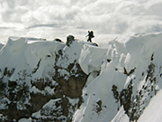
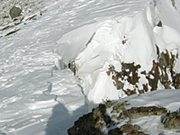
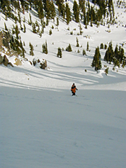
Another option, for the overnight trip or long day trip, is to head north to the ridgeline between Castle Peak and Basin Peak. From here, head northwest along the ridge until you find an obvious descent line at about 8,700’ to descend into Coon Canyon. Be wary of cornices along the north side of the ridge, which has vertical cliffs and is exposed to high winds from the southwest (photo 2). On our trip, a dog walking along the cornice caused a section about 15’ long and 4’ wide to suddenly fall, as seen in the photo at left (photo3). Luckily the dog was not swept away with it. There are several fine north-facing descents in the bowl of Coon Canyon, with the steep north face of Castle Peak looming above. The only drawback is that Coon Canyon is used by noisy snowmobilers who practice "high-pointing" and cut grooves in some of the descents.
The Photos:
Photo
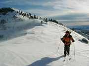
4 shows Davis-area backcountry skier Karl Benjamin traversing the corniced ridge
between Castle Peak and Basin Peak, with the eastern shoulder of Castle Peak
in the background. Photo 5 shows the north face of Castle Peak and various descents
along that side of Coon Canyon. Photo 6 shows Karl taking a breather during
the descent of the north face of Castle Peak into Coon Canyon.
Story and photos by: Erik Riegler
Back to Tahoe Country's
OUT N'ABOUT
Tahoe Country HOME
|
Shop our Tahoe Country Store Online © 1996-2003
(Jill Beede) |